Wednesday, March 5, 2014

LOCAL ICE: Photographing Cascade Glaciers before they disappear.


Heating Up


     A sensible person with their eyes open can see that the climate and environment of our planet is changing: increasing temperature, more frequent and violent weather, melting ice and rising sea levels are taking place.  Even if it is just another one of nature's cyclic spasms and we are not accelerating it, wouldn't we want, as humans, to lessen the effects of our activities on the earth, in order to preserve our habitat? The simple fact is that civilization has adapted to the planet and thrived based upon a state where: sea levels exist at their present level with many people living in places within a few feet of them, moderate temperatures (relatively speaking), and adequate resources (with a constant threat to destroying wild places to obtain more materials)                     


     In a sense our beautiful earth is being treated like a supermarket, where we stroll the aisles with the Costco mentality of stuffing our cart with a heap of cheap items, to sustain our comfy standard of living.     However in the upcoming years items like living space, arable land, clean air and water, will not be available at wholesale, for they are not being mass produced.  
     And I am by no means a saint, since I'm writing this on a computer probably manufactured in China.  While on that subject, where are the resources coming from to fuel their energy behemoth?  In part from us.  Coal!


     The British scientist James Lovelock has some dire predictions for the fate of the human race based upon massive alterations on the planet that he believes will occur.  He is by no means a dummy having invented the first aerosol disinfectant, developed a means to freeze and thaw animal sperm, and invented the Electron Capture Device that was used to measure the hole in the ozone layer caused by chlorofluorocarbons.  He is not basing his predictions on computer models, but on what is actually happening.   
     Satellite measurements indicate that ice is melting so fast that the Arctic Region could be ice-free by 2030.  The United Nations panel on climate change predicts that the Earth's average temperature will rise by 11.5 degrees by the year 2100, and that sea levels will rise 23 inches.  But the geologic record shows that when temperatures increased by 5 degrees 3 million years ago, the seas rose 80 feet!  Lovelock claims that computer modelers just do not know enough about the dynamics of melting ice sheets.


     Also Lovelock points out that cloud physics, deforestation, and the melting tundra all contribute to climate change.  And the Carbon Dioxide in the atmosphere is increasing.  The 7 billion people on the planet, plus livestock and pets, contribute 25 % of the total CO2, and the other 75%??  From a plethora of machines small and big spewing forth waste gases.  

The arteries of oil blanket the earth.
Pumping black energy to the thirsty masses.
Sever the steel lifelines, and we will all have to walk.

                                   How many noisy objects do we need?
                                   Of metal, glass, plastic and rubber?
                                   Suffocating the land and dominating our life.


Millions of moving things, 
so many loud metallic shiny things.
They run and cough and smoke, 
and sometimes even die and choke.
Busily streaming along where once grew plants,
like so many relentless soldier ants.
Eating up fuel, air and space,
What has happened to the human race?

                                              
     He refers to the Earth as a superorganism and has given it the name "Gaia" after the Greek goddess of the Earth.  According to his theory life is not just a traveler in a conveyance, but an active participant with the ability to alter the conditions that sustain it.  "If we as people do not respect and take care of the Earth, we can be sure that the Earth...will take care of us and, if necessary, eliminate us."


     Lovelock foretells that by 2020 there will be droughts and extreme weather, by 2030 the Arctic Ice will have disappeared, by 2040 the Sahara will move to Europe (with Berlin as hot as Baghdad), and by 2100 the planet's population of 7 billion (perhaps a lot more) will be reduced to 500 million.  The survivors will be living in the northern latitudes of Canada, Iceland, Scandinavia, and the Arctic Basin.  And anyone still around by then won't have to worry about their cable bill anymore.  Food, potable water, and shelter, will be infinitely more useful than a smart phone.
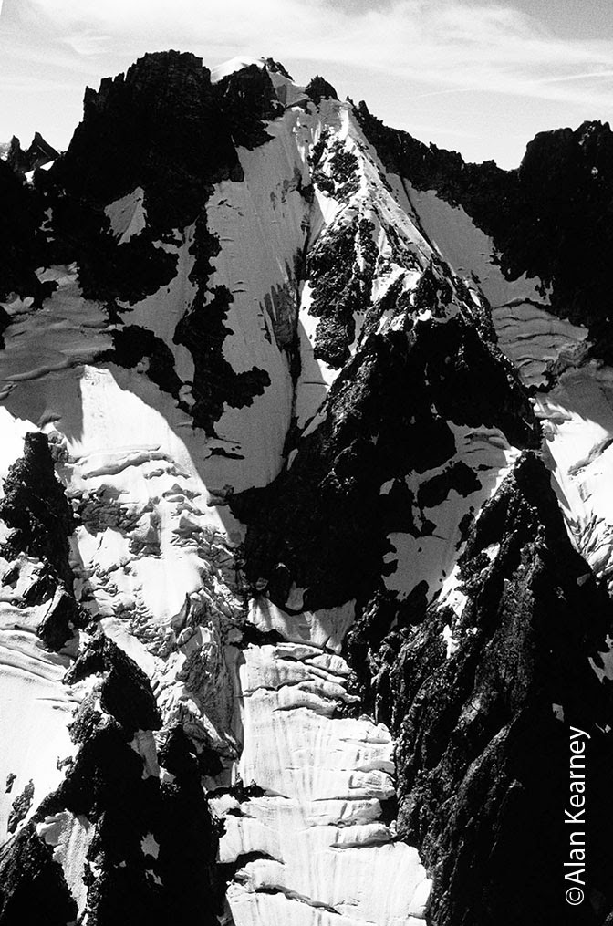


Cascade Glaciers

     It is not my place to make a definitive statement about our glaciers, but simply offer up these recent photographs of the change occurring. I live only 40 miles away from the most extensive collection (although none very big) of glaciers in the lower 48 states.  It is a fantastic opportunity to observe  these unique landforms closeup, something I have been doing since 1972.  Besides their obvious beauty, they are a major source of freshwater for people around the world throughout the year.  Long after the seasonal snows have disappeared in late summer, glacier ice continues to melt supplying streams and rivers.  That same freshwater is good for salmon and other species as well.


     A glacier is a permanent snowfield that has acquired enough mass and gradient to begin moving.  Old snow recrystallizes and metamorphoses into ice.  The tremendous pressure of the ice pressing down on bedrock causes melting, water acts as a lubricant and enables the ice to move by basal sliding.  The accumulation zone is high on the glacier where snow does not melt away entirely in the summer heat.  Snow compacts and eventually becomes ice.  These upper zones also receive snowfall in the summer, since even in the Cascades it sometimes snows during June, July and August.  Summer snows add little to accumulation, but the fresh white bright layer of new snow slows melting due to the albedo effect, or reflectivity of surfaces.   Of course when there is virtually no summer snowfall, and temperatures are hotter more melting occurs.  The video below shows meltwater streams going strong on the Easton Glacier in early October of 2012.


     The ablation zone is the the lower zone on the glacier where the years snow's is melting away; and in (September) one can sometimes observe the zone of demarcation between accumulation and ablation.  This is called the firn line.  Firn is a German word meaning old snow that has survived one or more seasons, and is in a state of transition to glacier ice.
     When accumulation exceeds ablation the glacier advances.  An advancing glacier is characterized by a bulbous snout of cleaner ice, and may even bulldoze down brush or small trees that grew up during a previous stagnant period.  A retreating glacier has a dirty tapered snout of ice, and piles and ridges of morainal debris nearby, (lots of examples in our Cascades).     


     As the river of ice moves down the mountain the brittle ice (upper 100 feet) cracks in response to the topography of the bedrock underneath, and differences in rate of flow.  Beneath 100 feet the ice is more plastic (like Silly Putty) due to the great pressure from the weight above.  Icefalls are those dramatic areas of the glacier where ice is moving rapidly over a steeper section or cliff of bedrock.  It cracks and shatters on every side, forming spectacular towers of ice; seracs.


     I didn't set out to document glaciers, but mainly to climb up or cross those icy fields to reach many of our craggy summits.  From 1973 to 2007 I always carried a good SLR camera; first an Olympus and then a Nikon loaded with Kodachrome early on, followed by Fujichrome later.  Since 2008 I have been using a digital Nikon with minimal lenses in the backcountry to save weight.  
    During those mountain adventures I captured many beautiful scenes, including glaciers from different perspectives.  Seven years ago I began to pull out some of my photographs of glaciers from the early 1980's, and realized that I ought to return to the same locations and reshoot those glaciers.  Taking with me an 8 x 10 color print of the original photo, I would  day hike, traverse several days, or climb to the summits where the originals were taken.  I have the uncanny ability to remember exactly what camera lens I was using, even 30 years ago, so then it was just a matter of getting to the same location late in the season (when the seasonal snow had melted away), and shooting from close to the same time of day, to produce similar lighting.
    The best perspectives were those that illustrated the difference in the surface area of the glacier, and were photos taken from oblique angles (sometimes even summits).  Photographs that show the glacier in profile or straight on, show the loss in thickness of ice better.  I have also included photos of getting to the locations, since that is such a big part of this story.


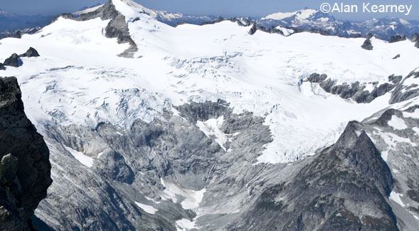
    Now for my photographic comparisons: the originals were photographed between 1981 and 1987, and the comparisons shot between 2005 and 2012.  Although I have a collection of about a dozen comparisons at this point, six North Cascade Glaciers are represented here.  They are the Coleman, Roosevelt, and Easton Glaciers on Mount Baker, the Le Conte and South Cascade Glaciers along the Ptarmigan Traverse, and the Inspiration Glacier on Eldorado Peak.  I will include the years the photograph was taken and the location in the photo captions.
     The easiest glacier to get to and take photos of, was the Coleman Glacier on the north side of Mount Baker; an uphill hike of about 2 1/2 miles.  I taught ice climbing on the Coleman Glacier all through the 1980's for a local guide service (and still do volunteer teaching for climbing clubs). 
    Even so when I began examining my old photos, I didn't have very many of the glacier from the best perspective.  But I think that the following images show the loss in ice thickness really well, and  the dramatic recession of the distant Roosevelt Glacier.


Coleman & Roosevelt Glaciers 1981- 2005 from 5700 feet on the Hogsback Path 

     As you can see from these first images, I took pains to return close to the same spot where the earlier photo was taken.  The next set of glacier images were shot along the Ptarmigan Traverse that follows the Cascade Crest from Cascade Pass south to Spire Point, and eventually Downey Creek. The classic traverse is one of my favorites in the range for scenic wonder, strenuous but not overly technical travel, and spectacular peaks, lakes, and glaciers.
     Planning a Ptarmigan trip during good weather is a must (mid July to mid Sept.).  One also needs five to seven days to appreciate the surroundings, and compatible partners who know how to travel safely on a glacier.  Finding the exact location of the next shot of the Le Conte Glacier below Old Guard and Sentinel Peaks was not nearly as easy as photographing the glaciers on Baker.  A alpine traverse is a much bigger time commitment, and a change in the weather on the crucial day can ruin the photographic mission.   I felt that we were on schedule for capturing the same light on the Le Conte Glacier as we crossed the Middle Cascade Glacier on day two.


     Once over the Spider/Formidable col, the climber's path traverses beneath the southeast side of Mount Formidable across talus slopes and snowfields.  Holding my 8 x 10 print in my left hand and ice axe in my right hand, I scrutinized the distant scene and tried to align Yang Yang Lakes up with the glacier.  I shot some preliminary photos, kept descending toward the lakes, and finally in a patch of heather before the path dropped off steeply, everything fell into place.  Using the same campsites as in 1981 helped us reach the photo locations close to the same time of day.


Le Conte Glacier 1981 - 2006 from about 6400 feet above Yang Yang Lakes

     The plan was to camp at Yang Yang Lakes that evening, enjoy the warm dusk light on the peaks while slapping mosquitoes, and then the following day continue the traverse.  Close to camp Mountain Monkeyflowers dotted the lush green moss, as the summits of Old Guard and Sentinel flamed red/orange in the evening.


     In the morning an adventurous black bear traversed the talus boulders with ease as we climbed toward the next photo location; the summit of Le Conte Mountain.  With only a rope, water bottles and snacks, we scrambled up toward what would become the most impressive view of a glacier on the traverse.  Once up the class three and four loose rock, we reached the airy summit where I pulled out my 8 x 10 print.  The South Cascade Glacier had receded dramatically in 25 years.  The tapered snout had pulled way back from the pea green morainal lake below the ice, and much bedrock was newly exposed.  The USGS has studied the South Cascade Glacier and the link below will take you to their data:    
                                          http://ak.water.usgs.gov/glaciology/south_cascade/

South Cascade Glacier 1981- 2006 from summit Mount Le Conte 7762'


     During the next five years I photographed several more glaciers in the Cascades (and even some in Argentine Patagonia), and finally last summer four in the North Cascades; the Inspiration, Boston, Terror and Easton Glaciers.   The 1982 photographs of the Inspiration and Boston Glaciers were taken from the summit of Forbidden Peak.  
     I planned a climb of Forbidden's West Ridge with a friend in late September.  The weather was supposed to be perfect except for possible smoke from recent forest fires.  If the wind direction changed, and the smoke drifted over Forbidden Peak and my target glaciers, any chance of completing my photo record would be thwarted.


     Although most color filters are no longer necessary with use on digital cameras, a polarizing filter remains essential.  Especially on days where there is a very thin high cloud cover that ruins the light, or in the case of even a little smoke, a polarizer eliminates much of the scattered light reaching the subject. By rotating it on the lens and viewing the scene through a single lens reflex camera's eyepiece, you can observe the scene improve.  There is no substitute for good direct light for making the best photographs.    Polarizers work best when the light is striking your subject from the side (90 degrees is optimum).  For the scene above with the sun overhead, a polarizer will do nothing.
     My partner and I picked a Tuesday and Wednesday for our West Ridge climb, got a permit from NPS in Marblemount, and stomped up the dusty steep path into Boston Basin.  We got a dawn start the next morning from the high bivvies in the basin, weaved up the wet rock slabs, and then cramponed up the shattered Taboo Glacier.  Ditching boots, axe and crampons a short ways above the glacier, we climbed rapidly up the dry gully adjacent the couloir (the couloir is broken up badly in late season), and onto the West Ridge.
    Forbidden is comprised of Eldorado Orthogneiss, and by Cascade standards is quite solid.  Climbing up the exposed ridge  was super fun; the day was clear (the smoke seemed to be lingering on the other side of Cascade Pass) and hardly any wind.  We shared the rocky spine with four lads from a Mount Rainier guide service on their days off.


     Once on the summit I shot my buddy traversing the very same spot that my previous partner had in 1982 after climbing the Northwest Face.  With my print in hand I directed my friend to nearly the same location, and then blasted away with my Nikon D90 using a 16 to 85mm VR stabilizing lens.  This is my current favorite zoom for use in the high alpine.  It covers a range of equal to 24mm to 127mm lens, and is compact and lightweight.  The following comparison photos reveal significant recession of the Inspiration Glacier.  This is purely a visual comparison and not a scientific one.


Inspiration Glacier 1982 - 2012 from summit of Forbidden Peak 8815'


          With cropped images one can get a closer look at the ablation zone of the Inspiration Glacier.


    Last in this collection of glacier photos is another one close to home, the Easton Glacier on Mount Baker's southwest side.  To get the shot it requires a hike of three miles and 1600 feet to a bench with tarns just below Park Butte.  All through the 1980's I spent a lot of time on Mount Baker teaching climbing, and a significant portion of that time on or near the Easton Glacier.  A typical class would last five days during which time we taught students all the right stuff to become a skilled alpinist on snow and ice.  On the fifth day, weather permitting, we would climb Baker up the Easton Glacier to the crater rim. 


     For my early photo of the Easton Glacier in 1987 I carried a 13 pound Korona Gundlach 8 x 10 view camera up to the tarns near Park Butte.  Of course in this digital age the concept of carrying and shooting film is difficult to grasp, but the Gundlach camera shot a sheet of color film that was 8 x 10 inches in size.  Each film holder had two sheets of film in it, and I carried five holders, ten exposures were possible on one trip.  The lens used was a Schneider 210mm Symmar, which was about equal to a 28mm wide-angle.  A hefty tripod, black cloth and light meter completed the equipment.  When I came across this 1987 photo I couldn't even scan it myself, had to take it to a lab where they did a flatbed scan of the Ectachrome transparency.  In the photos below one can clearly see the loss in thickness of the ice in 25 years, especially low on the glacier.


Easton Glacier 1987 - 2012 from 5000' on Park Butte

     I have included here two tighter shots of the Easton's snout (1987 - 2012), illustrating the loss in thickness better.


      Last summer 2013, I was fortunate to join Glaciologist Mauri Pelto for his ongoing glacier studies of Cascade Glaciers. He has been taking measurements and observations since the mid 1980's of the Columbia Glacier in the Monte Cristos, the Lower Curtis Glacier on Mt. Shuksan, the Shoals, Ptarmigan, Rainbow and Easton Glaciers on Mt. Baker, and the Lynch and Ice Worm Glaciers on Mt. Daniels. For a week in August I was able to accompany him and his crew on the Columbia, Lower Curtis, and Rainbow Glaciers. Below is a time-lapse sequence I photographed of his group taking measurements on the Rainbow Glacier, on Mt. Baker's eastern side.


   I have many more glaciers to photograph in the upcoming years; the Forbidden, Deming, Challenger and Lower Curtis Glaciers are tops on my list.  Check out my Vanishing Glaciers Photography Workshop coming this summer, where we will do day hikes to the Coleman and Easton Glaciers on Mt. Baker to further document the moving ice, and get great photos. Go to:  http://www.alankearney.com/glaciers.html to learn more about the special workshop.


Friday, November 1, 2013

Pickets Ski Traverse 2013


Dave Neff crossing the Challenger Glacier in 1973. Slesse in upper right.


     It all began in 1973 when my college buddy Dave Neff and I decided to attempt the Pickets Traverse in September, before classes started in the fall. Outfitted with REI Cruiser packs, stiff leather boots (Hanwag Rondoys for me Galibier Super Guides for Dave), wool clothing, ice axe, crampons, 120 foot rope, Stoppers screws, and a week's supply of food, we set out. A route description would have been useful, but someone forgot to bring it.
     Like many of my Picket adventures (135 days spent in the range over 22 trips) it approached epic status: things get difficult, weather hideous, or the unexpected happens. We did have nice weather for our climb of Challenger, but as we descended into Luna Cirque (one of two Pickets crucibles that render alpinists into jelly), wispy clouds began to appear overhead. Our 120 foot rope and four ice screws did not seem sufficient gear to tackle the ice face on Fury's northeast side (these days people ski it) as we tiptoed past.

Dave Neff below summit Mt. Challenger

Dave Neff at Luna Lake, Fury above
     Once out of the cirque we were puzzled as to how to continue the traverse on Fury's backside. Nothing was obvious, although we could look across McMillan Cirque (second crucible) and see the Southern Pickets. The craggy peaks seemed tantalizingly close, but there was a pesky brush-choked valley walled by cliffs in the way.
     Dave peered over the edge and suggested we down climb and rappel into McMillan Cirque, then climb straight up out the other side. Twelve years later Chris Copeland and Josh Lieberman attempted to do that after climbing Fury's North Buttress. In a whiteout they missed the left turn off the glacier leading back to Luna Cirque, and continued down to McMillan Creek. Hemmed in by a tangle of vine maple and slide alders they chose to make for Big Beaver Trail: it took them two days to travel four and half miles.
     I thought it would be the equivalent of stepping into quicksand: horrible wet muck that will be difficult to extricate one's self from. I refused. Dave got mad, hell bent on finishing the traverse as he was. We ended up retracing our route back to Luna Cirque, crossed the Challenger Glacier in a whiteout, and sneaked past tottering seracs on the East Whatcom Glacier.

Alan at Luna Pass 1973
     I made many excursions to the rugged little range reaching summits, or waiting in tents as it rained or snowed: sometimes never seeing the intended objective. But the climbs that added pertinent information in order to ski all the way through were: Fury's North Buttress, a winter attempt on East McMillans North Face, and a south to north traverse in the summertime.
     In September of 1992 Mark Price and I headed into the Northern Pickets for a climb of Mount fury's North Buttress.  We accessed the range from Chilliwack Lake in Canada, and the Chilliwack River Trail. The trail has long been neglected (on purpose due to the unguarded border) by North Cascades National Park. Yes, terrorism and drug trafficking does affect climber's access. That year was the last time I remember the trail being barely passable; now it is a nightmare of giant windfalls and overgrown trail. But it worked for us in 92, and we climbed over the top of Mount Whatcom, crossed the Challenger Glacier, and descended into Luna Cirque to camp at Luna Lake.

Northeast Face and North Buttress Mt. Fury from the air

     Nowadays I probably wouldn't even attempt to climb Fury in the autumn with the weather forecast that we had; one or two good days out of eight, the other six rain and snow. But I wanted to climb the route badly, and we did. Didn't quite make the summit however, and spent a cold night under a slight overhang, as a bushy-tailed woodrat harassed us. With down jackets only and a stove, we at least had hot drinks, but no sleep.
   
   
Mark Price on the North Buttress
     The climb itself was good but very long. The late
season made for more rock climbing down low (Beckey
and Davis in July of 1962 climbed a lot of snow to avoid
much of the rock). We didn't. And the days were short,
routefinding tricky, and pro not always where one wanted it.
    All those factors cost us time, the most precious of alpine commodities. Following the grim bivy (it began to rain during the night), we groped our way over the summit in wind, and rain, and got back to our tent at Luna Lake drenched and tired.
     My old and worn out single-wall tent had three inches of standing water on the floor, and pads, bags, and remaining food floated about like the flotsam from a torpedoed ship. We passed a grim three days squeezed together in our remaining dry sleeping bag, as outside a September storm lashed the cirque with wind, and dumped several inches of snow.  
     Nearly out of food and fuel, we decided to exit the Pickets via the cirque, skirt the Challenger Glacier on the northeast, and rappel slabs down into the head of Little Beaver Creek. It did work, and we got back three days later than expected; 7 days became 10.
  
     In 1996 Dana Hagin and I had a near-perfect non-epic trip into the range when we put up a new route on the Northeast Buttress of Inspiration Peak (see my blog about it on this website). Four years later with Carl Skoog, I climbed The Pyramid and normal route on East McMillan Spire. Both trips had great weather, went according to plan, and finished on time. But when that occurs in the Pickets you feel as though you are treading on thin ice; at any moment (probably the next visit) one is likely to plunge headfirst into the murky, wet, terror the serrated peaks are so famous for.

     Seven years later Dana and I attempted to climb the North Face of East McMillan Spire in winter (its still awaiting a first winter ascent), and it was one of the hardest trips I've done into those remote peaks. Our packs were super heavy, loaded with ten days food and fuel, plus climbing and camping gear for winter. And as is so often the case in the Cascades, timing with the weather was everything.

North Face of McMillan Spires in winter
     On the approach to East McMillan the weather was perfect (and had been for ten days or so creating good conditions), but as we got to the base and bivied, it changed. We got about a quarter of the way up the face on some of the best mixed climbing I've ever done; styrofoam hard snow coating steep corners and ramps. But the temperature warmed up dramatically while we were climbing, and the good conditions deteriorated. It was frustrating, but did add much to my knowledge of the Pickets in winter, and especially the entrance into McMillan Cirque.

Dana Hagin on the North Face of East McMillan Spire in February

     In 2008 I was finally able to completer the traverse of the Pickets from south to north with Shawn Olson. During the third week of July we started the trip up Goodell Creek, crossed Terror Creek, and climbed steeply up onto the Barrier. On day two the sky remained clear as we traversed into Crescent Creek Basin, and kicked steps up steep snow to the Himmlehorn/Ottohorn Col. Dark clouds materialized from nowhere (as is often the case in the Piglets), as I prepared anchors for us to rappel to  the Mustard Glacier below. Shawn was not excited at the prospect of dropping into the unknown.
     Once down and onto a small rock island, we made camp and watched it rain and snow for two days. Late on the second day it seemed to be clearing a bit, and we quickly packed up, and traversed to Picket Pass just before dark.
   
     It was tight making it to a good campsite in
Shawn Olson near Picket Pass
time but the shreds of evening mist floating by, and the jagged Crescent Creek Spires in the background made up for it. 
     Perfectly flat grassy benches surrounded by heather and stunted Mountain Hemlocks dotted the pass. If not for having to finish the traverse, we might have never left that idyllic spot in the high mountains.
     We lingered over morning coffee, shot photos, and dried out damp socks in the warm morning sun. In the distance the entire Southern Pickets created a stone fence that punctuated the blue sky.


Shawn Olson st Picket Pass in the morning

     Day five began clear, but increasing clouds developed into a downpour. As we neared Luna Pass it was getting late, and every flat spot was filled with water. We opted for a large slightly sloping boulder to pitch the single wall tent on, in the hopes the rain would at least drain away. No chance of getting up Luna Peak in that storm. everything was soaked, and in the morning I sponged several cups of water out of the bottom of the tent.


Shawn Olson crosses outlet of Luna Lake
    Under overcast skies we threaded our way down to Luna Lake between narrow cliffs, crossed the outlet of the icy lake, and slowly did a rising traverse toward the northwest edge of the cirque and a good campsite.
     With seracs above and cliffs below, there is only one reasonable way up and out of the huge glacial-carved bowl. And since I hadn't been there since 1992, the route info would become useful when skiing it in 2013. 
     That night it did not rain, and the tent began to dry out. I had hoped the traverse would not have required all eight days of food we carried, but waiting on the Mustard Glacier had eaten up time and supplies. Although an ascent of Challenger would have been fun on day seven, we passed it up as the peak winked in and out of low clouds.
     The Eiley/Wiley High Route to Beaver Pass was tricky and a lot steeper than I remembered from as solo trip in 1991. Morning dew covering incredibly steep heather and hellabore slopes, called for the use of ice axes (piolet turf is my favorite term for such terrain). Once off the traverse we descended brush between cliffs to reach the pass. One more long day on easy trail, got us to Ross Dam and the end.


     I really got psyched about trying to ski the Pickets Traverse when I skied the Ptarmigan Traverse with Carl Skoog in 2002. I asked him questions about his 1985 May traverse with brother Lowell and Jens Kieler (the first time the range had been skied). With the summer traverse under my belt, it was a matter of getting in shape, and finding a willing partner.
     Kyle Breakey took the Mountaineers Basic Climbing course several years ago, and was already a hot skier.  He joined me on a Bear Mountain climb in 2012, and was keen to do more in the alpine. In the early part of 2013 the weather was not cooperating for extended periods. Then finally in late March it looked as though we were going to get six days of clear skies; and there would be sufficient snowpack in the bottom of McMillan Cirque (the lowest point on the traverse).
     The plan was to hike up Sourdough Mountain from Diablo, then ski out Stetattle Ridge west, drop into McMillan Cirque, up and around Luna Peak, Luna Cirque, Challenger Glacier, Easy Ridge, Mineral Mountain, Chilliwack Pass, and Hannegan Pass. I packed food for six days; it weighed eight and a half pounds, and was barely enough. Taking a tarp and leaving the tent saved two pounds, but made for grim living on two nights.


Ski Traverse from Diablo to Hannegan Pass
     On March 30th we started up Sourdough Mountain with packs loaded and skis strapped on. Still a good 1500 feet below the ridgecrest, we encountered Steph Abegg, Mike Torok, Matt Burton and Carla Schauble on snowshoes. They were out for two days and a climb of Sourpatch, just northwest of Sourdough. Forn straight up work snowshoes are good, and with lighter packs they outdistanced us easily. That first evening Kyle and I skied a couple miles west on then ridge and pitched our tarp between some Mountain Hemlocks. It was then first of two times we used it.

First night's tarp camp on Stetattle Ridge


     For most of the trip we built snow forts to cut the wind, and it enabled quicker starts in the morning not having to stuff frozen fabric, and fiddle with knots.

Cornices on Stetattle Ridge


     We made some miles on day two, dropped in and out of the big dip east of Elephant Butte, and quit early just SW of the butte when mushy slopes threatened to slide. It was a perfect evening in the high mountains as we cooked dinner inside snug snow walls. I was a bit alarmed at how much fuel we had used on the previous night, and vowed to preheat the Whisperlite with starter paste, and melt snow with black bags whenever possible.  


Kyle in snow fort below Elephant Butte

     A warm dawn light washed over Peak 7200 on April 1st as we sipped coffee, and contemplated the day's efforts. Getting in and out of McMillan Cirque was potentially one of the trip's cruxes.


Moon at dawn, Peak 7200
    Spirits were high, and just to be near the Pickets only ten days after the official "end" of winter was exhilarating in itself.
     Just ten years ago Dana and I had trudged up out of Stetattle Creek with the icy walls of 7200 for a backdrop; just another nameless peak in a range of 1100 summits.  
     Time to get packed up: dried out items like insoles and sox come off our warm chests and into boot liners, the stove and precious fuel is packed away as if it were a multi-million dollar satellite heading for Mars, check the taped feet, roll the 3/4 therma rest as tight as possible, cram small items deeply in pack leaving no empty spaces, scrape nighttime ice off skis, one last sip of coffee, into boots and reef down buckles, stomp into bindings, pack on and tighten waistbelt.

Breaking camp at dawn, Stetattle Ridge


     We're finally moving! On across the long smooth slopes we slid towards East McMillan Spire in the distance, its jagged tooth of Skagit Gneiss frosted with March snow. At then 6300 foot saddle east of McMillan, finally a look into the forebidding cirque with the same name. After a quick snack and drink, we plunge over the side, at first just booting, then below don skis again. Soon we're carving through a half foot of powder on a descent into the giant arena.

Kyle begins the descent into McMillan Cirque
      But the fun doesn't last, and soon it is not obvious how to reach the bottom easily. A traverse westward keeps us above cliffs, and to avoid one nasty chasm we must climb even higher, attach ski crampons, get out our axes, and gingerly shuffle across an ice avalanche gutter. We should have stopped and put on the real crampons, but we got hasty. That was followed by bad snow, and rollovers that prevented a straight shot at the bottom.
      Kyle took one spill and stopped, then below we had to boot down s short bit to gain gentle slopes in the bottom.
     A needed lunch break was in order, then find a way to cross McMillan Creek, which appeared to have snow bridges.
Making turns below McMillan, inspiration and Terror

     The creek was spanned by what looked to be thick snow in places, and with Kyle a bit out of view, I tried gliding across one. In the heat of midday it gave way, dumping my headfirst toward the creek. I was upside down, one ski buried deep and my boot attached, the other dangling from the safety strap. Lucky for me there was a boulder just above the water's surface, and I was able to step down, and then spend ten minutes extricating my buried ski. Nothing injured, no damage to skis. Stupid and lucky.

Our route out of McMillan Cirque and over to Luna
    From  the debacle in the creek we skinned up a rubble-filled chasm toward the southeast side of Fury. this was the most nerve-wracking place of all as there was plenty of recent avalanche debris in it. But there appeared no other way up out of the cirque.
     About two thirds of the way up it, I suggested we climb up onto a rock ledge twenty feet above the gutter and take a break. While drying out boot liners, we figured a way to climb up to the east, and avoid getting flushed in the chute.

   
     The canyon fell into shadow as we ascended to a headwall, and our campsite for the night.

Kyle at dinner below Mt. Fury


We were happy to at least ben out of the bottom of McMillan Cirque, but to completely escape it we still had to climb 1100 feet of steep hart snow in the morning. Just before dinner a big slide creamed our ascent route. We needed a cold night, and an early start to make it up the broad gully before the sun hit it.

Kyle nears the big gully
     With the aid of belays, slings around small trees, and a few Stoppers in the rock, we cramponed carefully up to safe slopes on the southeast side of Mt. Fury. Already the sun was hitting the East Face of Outrigger Peak to the southwest, causing slides.
     My eight-point steel crampons bit into the hard snow, and I was glad my pack was no heavier than it was now that my skis were strapped on. It was a tense bit of work, not knowing for sure if sun-warmed slopes above us would cut loose.
     At the last trees and into the sun, we unroped, took a break, and skinned up. A rocky spur up and to the east, looked like a good spot for a longer break, and some black bag snow melting.
    Because of the warm weather our traverse was a juxtaposition of joy and anxiety: the joy of being in spectacular surroundings, and the anxiety of constantly monitoring snow conditions, and aspects.
     We didn't smile much at dinner time now. The slope below Luna Peak was about halfway, and at 2 in the afternoon it was roaring with one avalanche after another. To go on, to wait, or to exit the traverse down and out Access Creek to Big Beaver were our options.


     We discussed the situation thoroughly and decided to wait for four hours, and see if the slope up to luna Pass would freeze once it fell into shadow. Our black bags were melting more snow as another element of anxiety entered our world; changing weather, with moisture clouds coalescing over the Southern Pickets.

Approaching storm over Southern Pickets


     The slope above did freeze, and we skinned, booted, and cramponed up over the pass at 10:30 pm.

Luna Pass at night
     The runnels from slides were frozen hard and steep. Crampons were essential on the hard crust that sometimes collapsed, giving way to knee-deep mush beneath.    
     Five hundred feet below the pass and into Luna Cirque, we finally stopped and built our fourth snow fort. Fury shown bright and clear in the morning, as we munched pop tarts and drank coffee.
     Tired feet went slowly into stiff cold boots, and I handed Kyle back the foam from inside his pack; it had been under my feet as I had brought a partial Therma Rest. My square of pack foam was snatched away by the wind two days before.

The peaks of Luna Cirque
     Kyle had the right idea about dropping down to Luna Lake, and I picked the harder way cause I couldn't see the bottom of his route. Later, looking back, we could see it went. But there have been many times in the mountains in summer and winter, I've had to climb back up out of wrong turns.
     Alpinists have also made fatal mistakes by not retracing their wrong turn, and attempting to force a way down where its too difficult. Several days later at Chilliwack Pass, it was his turn to call me out, and insist on the longer, safer way.

     Luna Cirque provided the best corn run of the trip, as we zoomed past Luna Lake in a long crispy glide.

Kyle pauses below Mt. Fury
     The day was cooler, and the avalanche activity much reduced. A scant 30 minutes was spent in the bottom, before deciding it was safe to get up and out of there.
     From the northwest edge of Luna Cirque our route lay across the gentle Challenger Glacier; our destination Perfect Pass. As we started across roped up, the sky was clear, but a cloud bank lingered low on the west edge of the ice field.
     The pass winked in and out of the clouds, and then as we neared it, became completely obscured by fog. We groped upwards beneath a giant cornice that loomed eerily through the mist.
     Kyle reached what he thought might be the pass, but there was no way to tell for sure. We were tired, it was late, the wind had picked up, and it started snowing. We dug a half cave, and pulled ourselves in, like overgrown Hermit Crabs trying to fit in shell too small.
     But it gave us some protection from the damp wind, and especially a place to put the stove and cook. It was the last night we still had food for a dinner. I hoped that the fuel would hold out for making hot drinks, and of course melting snow.


Kyle at Perfect Pass on the morning of day 6

     Our sleep was fitful not knowing what hazards and routefinding difficulties still lay ahead. Next morning our skis were rimed up, everything was soaked, and boots were snowy.

Boot shells at Perfect Pass

     The fog was beginning to thin, and we were optimistic we'd have enough viz to find our way down off the pass. Kyle scoped a steep gully that led to easier slopes below, and from there we hiked downward and toward Imperfect Pass.


Carrying skis down toward Imperfect Pass
   
     The plan was to try and stay high, and cross the tricky chasm known as Imperfect Pass. Clear skies and hot sun caused snow to slide off the rocks above, and the chute was scoured every five minutes with slushy slides. And although Kyle did his best to place some gear, and find a way across, it was the wrong place to be.

Kyle tries some mixed moves at Imperfect Pass
     We pulled back, studied the map, and found a circuitous but much safer way down to the south. It was the same route I'd climbed up in 1973 when I first attempted the traverse.
     Once down off the steep terrain, we took a long break, and dried out our wet gear; no sense packing all that water weight. The black bags were working hard to melt snow for drinking water, and we retaped feet.
     It was day six, and the end was still a long ways off. We'd have to climb over Mineral Mountain in the dark, to make up for the time lost at Imperfect Pass.

Kyle gliding toward Mineral Mountain at sunset

     Kyle led off northwesterly along Easy Ridge. Just before sunset, we had beautiful corn skiing above a small lake just east of Mineral. With headlamp on he did a great job finding the way up the smooth firm slopes on Mineral's east side. We reached the summit at 10:30 at night, too tired to even shoot a flash photo of our only summit.
     Several hundred feet below the top on the west side, we stopped in the lee of a boulder and dug a snow fort. Dinner for me consisted of a packet of Miso soup. It was the night of April 4th; the night we were supposed to be back. We were still a full day from finishing, and maybe more.
     Day seven did not go according to plan. My idea of dropping down to Chilliwack Pass, was thwarted by steep unstable slopes. The incoming storm had warmed the air a lot, and slopes that were firm, turned to mush. We dropped off the ridge to the north, wound down through thick woods, and crossed the Chilliwack River where it was shallow.

Kyle after crossing the Chilliwack
     From the other side there was no way to identify the Chilliwack River Trail under all the snow. And on the southern slope below Copper Ridge deep ravines sliced the terrain. Our best bet was to skin straight up to the ridge, then follow it westward toward Hannegan Pass.
     We did, it was hard, and we were functioning on limited rations. Snow mixed with rain and wind, came out of the sky as we gained the ridgecrest at dark. A snow fort in amongst the hemlocks provided walls for our tarp, which we needed badly.
     Kyle was beginning to get cold, so I told him to crawl inside, and I'd finish tying out the guy lines. Dinner was two mugs each of hot tea with milk and sugar, and then to bed. Wet sox, damp boot liners, and gloves all went inside our bags.
     It was day eight and we HAD to get out. Coffee for breakfast, and cram wet stuff into packs. Running on a piece of chocolate, and a Cliff Shot fueled me on out the ridge, over Hannegan Pass and toward the road.
     Just as we started skiing the road a snow machine zoomed up (Kyle was out of sight ahead of me), and asked me if I was one of the overdue skiers. I said "yes" and the guy said; "do you want a ride?" and I replied; "Did my friend accept a ride? he said "yes."

Avalanche debris in Ruth Creek on day 8
          It was nice to know that our friends and relatives did care about us. I had no second thoughts about getting some help, the first time in forty one years of climbing and skiing in the Cascades.
     I have always hoped that my enthusiasm for the mountains will sometimes rub off on others, to perhaps inspire them to go out there. Or that my teaching climbing will pass on the many tricks, and techniques for being safe and having fun in the alpine.
     The knowledge I've gained from those who went before enabled Kyle and I to complete the fourth complete traverse of the Pickets on skis.


End of trip leftovers

     And contrary to what people might have thought; we were not completely out of food. There was even a half cup of fuel in the stove. Maybe not enough to power a rover on the surface of Mars, but it could have kept me going on into day nine.